
About the journal
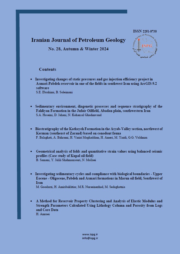
Iranian Journal of Petroleum Geology
Recent Articles
-
Open Access Article
1 - Investigating changes of static pressures and gas injection efficiency project in Asmari-Pabdeh reservoir in one of the fields in southwest Iran using ArcGIS software
Seyed Ehsan Ebrahimi ، Bahman Soleimani *Issue 28 , Vol. 14 , Autumn_Winter 2024 -
Open Access Article
2 - Sedimentary environment, diagenetic processes and sequence stratigraphy of the Fahliyan Formation in Jufair field, Abadan Plain, southwest of Iran
SeiedAghil Hoseini * ، Davood Jahani ، Nader Kohansal GhadimvandIssue 28 , Vol. 14 , Autumn_Winter 2024 -
Open Access Article
3 - Biostratigraphy of the Katkoyeh Formation in the Asyab-Valley section, northwest of Kerman (southeast of Zarand) based on conodont fauna
firozeh balaghati ، Ali Bahrami * ، Hosyen Vaziri moghadam ، Hamed Ameri ، Yazdi Yazdi ، Gustavo Gabriel VoldmanIssue 28 , Vol. 14 , Autumn_Winter 2024 -
Open Access Article
4 - Geometrical analysis of folds and quantitative strain values using balanced seismic profiles (Case study of Kupal oil field)
Babak Samani * ، Yaghoub Jalili ، Negar MollaeiIssue 28 , Vol. 14 , Autumn_Winter 2024 -
Open Access Article
5 - Investigating sedimentary cycles (cyclostratigraphy) and compliance with biological boundaries - Upper Eocene - Oligocene in Pabdeh formations (upper part of Pabdeh formation) and Asmari in Marun oil field.
Mohammad Goodarzi * ، Hassan Amiribakhtiar ، kheyrolah Nuraeinejad ، Mostafa SedaqgatneiaIssue 28 , Vol. 14 , Autumn_Winter 2024 -
Open Access Article
6 - A Method for Reservoir Property Clustering and Analysis of Elastic Modulus and Strength Parameters Calculated Using Lithology Column and Porosity from Logs and Core Data
Hamed Amraei *Issue 28 , Vol. 14 , Autumn_Winter 2024
Most Viewed Articles
-
Open Access Article
1 - Studying Maturity and Migration Routes Using Two-Dimensional Modeling in a number of Dezful Dam Oilfields
Ashkan Maleki ، Seyed Ali Moallemi ، Mohammad Hossein Saberi * ، Mohammad Hassan JazayeriIssue 17 , Vol. 9 , Spring_Summer 2019 -
Open Access Article
2 - Study of Petrography & Petrophysics of Permian- Triassic carbonate sediments in Qatar –South Pars Arch
Ali reza BashariIssue 7 , Vol. 3 , Spring 2014 -
Open Access Article
3 - Interpretation of sedimentary environment and factors affecting reservoir quality in upper Sarvak Formation in one the oil fields of Abadan plain
Arad Kiani ، Mohammad Hossein Saberi * ، Bahman Zare nejad ، Elham Asadi ، Nasim RahmaniIssue 16 , Vol. 8 , Autumn_Winter 2019 -
Open Access Article
4 - Biostratigraphy of the Gurpi Formation Based on Planktonic foraminifera with emphasis on the Cretaceous-Paleogene boundary in Jahangirabad Section, Kabirkuh Anticline, SW Iran
Alireza Ashouri * ، Samira Rahimi ، Abass Sadeghi ، Abbas GhaderiIssue 14 , Vol. 7 , Autumn_Winter 2017 -
Open Access Article
5 - Microfacies analysis, Sedimentary Environment and Sequence Stratigraphy of the Qom Formation in the Naraq area
Alireza Ashouri * ، Asma Aftabi arani ، Jahanbakhsh Daneshian ، Abbas Ghaderi ، Mohammad Reza Aria NasabIssue 19 , Vol. 10 , Spring_Summer 2020 -
Open Access Article
6 - Cyclostratigraphy study of Asmari reservoir in Karanj, Paranj and Parsi oil fields
Ardavan Khalili ، Hosyen Vaziri moghadam * ، Mehran ArianIssue 20 , Vol. 10 , Autumn_Winter 2021 -
Open Access Article
7 - Biostratigraphy and microfacies analysis of the Shahbazan and Asmari formations (through Eocene to Oligocene) in the carbonate deposits of northwest Dezful Embayment, Zagros Sedimentary Basin
sepedeh Gholampoor-moghahi ، Hosyen Vaziri moghadam * ، Naser Arzani ، Afshin ArmoonIssue 13 , Vol. 7 , Spring_Summer 2017 -
Open Access Article
8 - Biostratigraphy and sedimentary environment of Asmari Formation in Davan section, North of Kazerun
masood khoshnood * ، Hosyen Vaziri moghadamIssue 12 , Vol. 6 , Autumn_Winter 2016 -
Open Access Article
9 - Biostratigraphy and microfacies of the Dariyan Formation in east of Gachsaran (Anneh anticline)
Samaneh Solymani-Ahmadi ، Hosyen Vaziri moghadam * ، Ali TaheriIssue 16 , Vol. 8 , Autumn_Winter 2019 -
Open Access Article
10 - Biostratigraphy, conodont biofacies and CAI of Late Devonian-Carboniferous deposits in Anarak section, Central Iran
ٍٍElahe Sattari ، Ali Bahrami * ، Hosyen Vaziri moghadam ، Ali Taheri ، Sandra Isabella Kaiser ، Peter KönigshofIssue 18 , Vol. 9 , Autumn_Winter 2019